Test project for providing information on distance between airports.
Description of the test task:
Build a REST service to measure distance in miles between two airports. Airports are identified by 3-letter IATA code.
Sample call to get airport details: GET https://example/airports/AMS HTTP/1.1
Requirement:
- dotnet core 2.0 or later has to be used. Allowed to use 3-rd party components.
The main purpose of the development of this software is to provide functionality for calculating the distance between airports using IATA airport codes. An IATA airport code, also known as an IATA location identifier, IATA station code, or simply a location identifier, is a three-letter geocode designating many airports and metropolitan areas around the world, defined by the International Air Transport Association (IATA). The characters prominently displayed on baggage tags attached at airport check-in desks are an example of a way these codes are used. link
Before starting the development, it should be noted that the geographical coordinates of airports change very rarely and the most optimal in terms of performance is the approach of obtaining pre-calculated data (saved in the program's metadata).
| Verb | Resource | Parameters | Status Code | Responce body | Description |
|---|---|---|---|---|---|
| GET | /api/v1/distances | from - Departure airport IATA code to - Destination airport IATA code |
200 - Ok 400 - Bad Request 404 - Not Found |
DistanceResponse | Calculate distance between airports |
DistanceResponse{
miles*	number($double)
}The following three algorithms for calculating the distance by geographic coordinates are most commonly used:
- Vincenty's formula is very complex and very slow, but very accurate. link. (The algorithm may give an inaccurate result of 0.5 mm)
- Haversine simple but not very accurate value link. The approach has problems with an accuracy of 0.5%. (from 0.42% at a distance of 300 meters, to 0.78% at a distance of 10,000 km)
- Spherical Law of Cosines is a simple and fast algorithm that works over short distances. link There is a problem of accumulation of error from an increase in the distance from 0.27% for a distance of 100 km to 72.56% for a distance of 5000 km.
Excellent description of geo distance calculation approaches and performance improvements Haversine's algorithm using approximation and Taylor series, can see here.
To implement the business logic for calculating the distance between airports, we will choose the Haversine algorithm. This algorithm is fast, reasonably accurate.
To improve performance, I will use the database. This database will be used rather as a cache for serving dynamically calculated data. In this service, between the bases of service instances, there may be no synchronization, because they perform simple math operations and Embedded base can be used. I wanted to use the NOSQL embeddable LightDB. Tests have shown that this is a small and high-performance data base but unfortunately it didn't have asynchronous functions. For the implementation of the data storage, I chose the SQLite database, this is an embedded implementation database. In the future, if the requirements for scaling and fault tolerance of the program change, the base can be replaced by another implementation, such as postgresql/mssql.
IATA airport codes is a three-letter geocode in uppercase. The Internet database of IATA airport codes contains approximately 10,000 entries. The maximum combinatorial combination of 26 English characters in three positions (Permutations with Repetition) 17576. The database will store a pairwise combination of IATA codes without repeating. If the combination {А, В} is present in the database, it will be impossible to add the combination {В, А}, they are equivalent (Combinations without repetition). The database will contain a maximum of 154449100 or for a base of 10000 codes 49995000 records. Each record will contain two fields of three ASCII characters and one double field = 112 bites = 14 byte. Maximum database size can be ~ 4.027 GB or database size for 10000 actually existing IATA codes ~ 0.652 GB (I'm talking about pure data, there are also overhead costs of the database data structs as a cluster index).
This project is designed using the hexagonal architecture style.
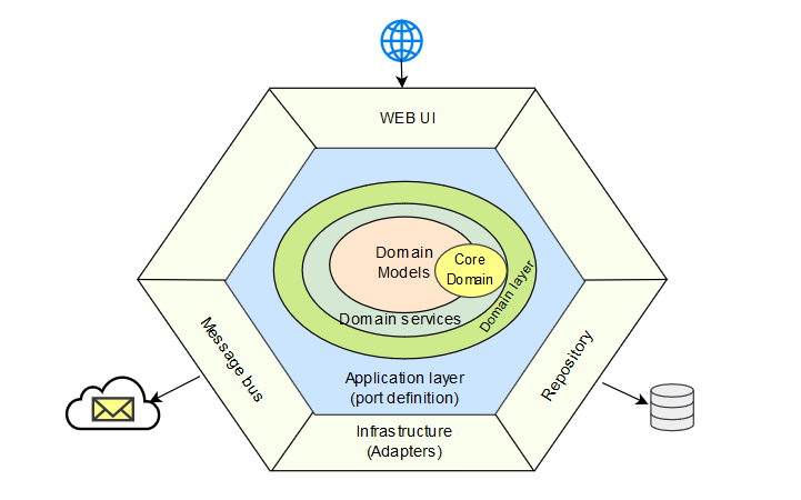
The hexagonal architecture, or ports and adapters architecture, is an architectural pattern used in software design. It aims at creating loosely coupled application components that can be easily connected to their software environment by means of ports and adapters. This makes components exchangeable at any level and facilitates test automation. The hexagonal architecture directs all dependencies to the center of the external infrastructure adapters in the domain layer. More information in other my pet project.